© Dominik Ketz

Auf Jägers Pfaden - On the hunter’s trail (especially for e-bikes)

Short facts

  • start: Kirchplatz, Much
  • destination: Kirchplatz, Much
  • medium
  • 34,04 km
  • 2 hours 32 minutes
  • 411 m
  • 373 m
  • 149 m

best season

Fachwerk - Wiesen - Auen

From Kirchplatz in Much, the route takes you along Hauptstraße in the direction of Drabenderhöhe. Burg Overbach, dating from the 15th century, is to the left of the route. In the district of Niederwahn, you continue on via Roßhohn and Oberdorf to Henningen. From there, you soon come to the highest point in the municipality of Much, Heckberg, which offers marvellous views as far as the Siebengebirge. From there, the route turns right through a forest area to the district of Drabenderhöhe and then on in the direction of Marienfeld. Behind Ophausen, the route runs along a cycle path along the secluded Bröl river. Shortly before you come to the dam, you turn right, up to the idyllic Tüschenbonnen. The route then goes uphill over Birrenbachshöhe to Wohlfahrt and then down into the Wahnbachtal valley. Downhill past Herrenteich to Sommerhausen along a ridgeway that offers fantastic views. Shortly after this, you come to the main town of Much.


Highlights along the route:


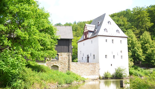
- Burg Overbach Golf Course: The 18 hole golf course at Golfclub-Burg-Overbach e.V. founded in 1985 surrounds the medieval Burg Overbach on 85 ha of extensive, pristine countryside. The golf course is considered to be one of the most varied in the region.


- Much Forest Open Air Pool: In 2007, Bürgerstiftung Waldfreibad Much rescued the open air pool from closure. With great commitment, a little paradise was created, where families, the elderly, disabled people and visitors can enjoy the cool waters.


- Saint Martin’s Church: The Catholic parish church of St. Martin in the historic town centre is part of a protected ensemble together with the timber-framed houses in the church square. The beautiful, salmon-coloured building, including the tower and nave, date back to the 12th century.


- Saint John the Baptist: The structure of the church in Kreuzkapelle dates back to the 12th century and is a Romanesque single-naved quarrystone building which is noted for its stout construction. One of the bells dates from 1433.


- Heckberg: Heckberg, at a height of 383 m with two summits is approx. 5 km north of Much and is the highest point in the forested area of Heck. The Heckberg nature conservation area, covering approx. 2.8 ha, is on its eastern flank.

Weather

Good to know

More like this

Next steps

It appears that you are using Microsoft Internet Explorer as your web browser to access our site.

For practical and security reasons, we recommend that you use a current web browser such as Firefox, Chrome, Safari, Opera, or Edge. Internet Explorer does not always display the complete content of our website and does not offer all the necessary functions.